Mark Dominus (陶敏修)
mjd@pobox.com

Archive:
| 2026: | JFMAMJ |
| 2025: | JFMAMJ |
| JASOND | |
| 2024: | JFMAMJ |
| JASOND | |
| 2023: | JFMAMJ |
| JASOND | |
| 2022: | JFMAMJ |
| JASOND | |
| 2021: | JFMAMJ |
| JASOND | |
| 2020: | JFMAMJ |
| JASOND | |
| 2019: | JFMAMJ |
| JASOND | |
| 2018: | JFMAMJ |
| JASOND | |
| 2017: | JFMAMJ |
| JASOND | |
| 2016: | JFMAMJ |
| JASOND | |
| 2015: | JFMAMJ |
| JASOND | |
| 2014: | JFMAMJ |
| JASOND | |
| 2013: | JFMAMJ |
| JASOND | |
| 2012: | JFMAMJ |
| JASOND | |
| 2011: | JFMAMJ |
| JASOND | |
| 2010: | JFMAMJ |
| JASOND | |
| 2009: | JFMAMJ |
| JASOND | |
| 2008: | JFMAMJ |
| JASOND | |
| 2007: | JFMAMJ |
| JASOND | |
| 2006: | JFMAMJ |
| JASOND | |
| 2005: | OND |
Subtopics:
| Mathematics | 250 |
| Programming | 102 |
| Language | 97 |
| Miscellaneous | 75 |
| Book | 50 |
| Tech | 49 |
| Etymology | 36 |
| Haskell | 33 |
| Oops | 30 |
| Unix | 27 |
| Cosmic Call | 25 |
| Math SE | 25 |
| Law | 23 |
| Physics | 21 |
| Perl | 17 |
| Biology | 16 |
| Brain | 15 |
| Calendar | 15 |
| Food | 15 |


Comments disabled
Thu, 10 Dec 2020
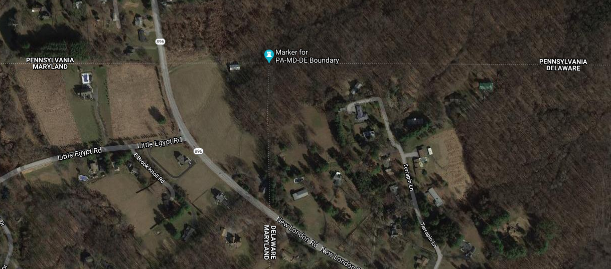
I see that the Pennsylvania-Delaware-Maryland triple border is near White Clay Creek State Park, outside of Newark, DE. That sounds nice, so perhaps I will stop by and take a look, and see if there really is white clay in the creek.
I had some free time yesterday, so that is what I did. The creek is pretty. I did not see anything that appeared to be white clay. Of course I did not investigate extensively, or even closely, because the weather was too cold for wading. But the park was beautiful.
There is a walking trail in the park that reaches the tripoint itself. I didn't walk the whole trail. The park entrance is at the other end of the park from the tripoint. After wandering around in the park for a while, I went back to the car, drove to the Maryland end of the park, and left the car on the side of the Maryland Route 896 (or maybe Pennsylvania Route 896, it's hard to be sure). Then I cut across private property to the marker.
The marker itself looks like this:

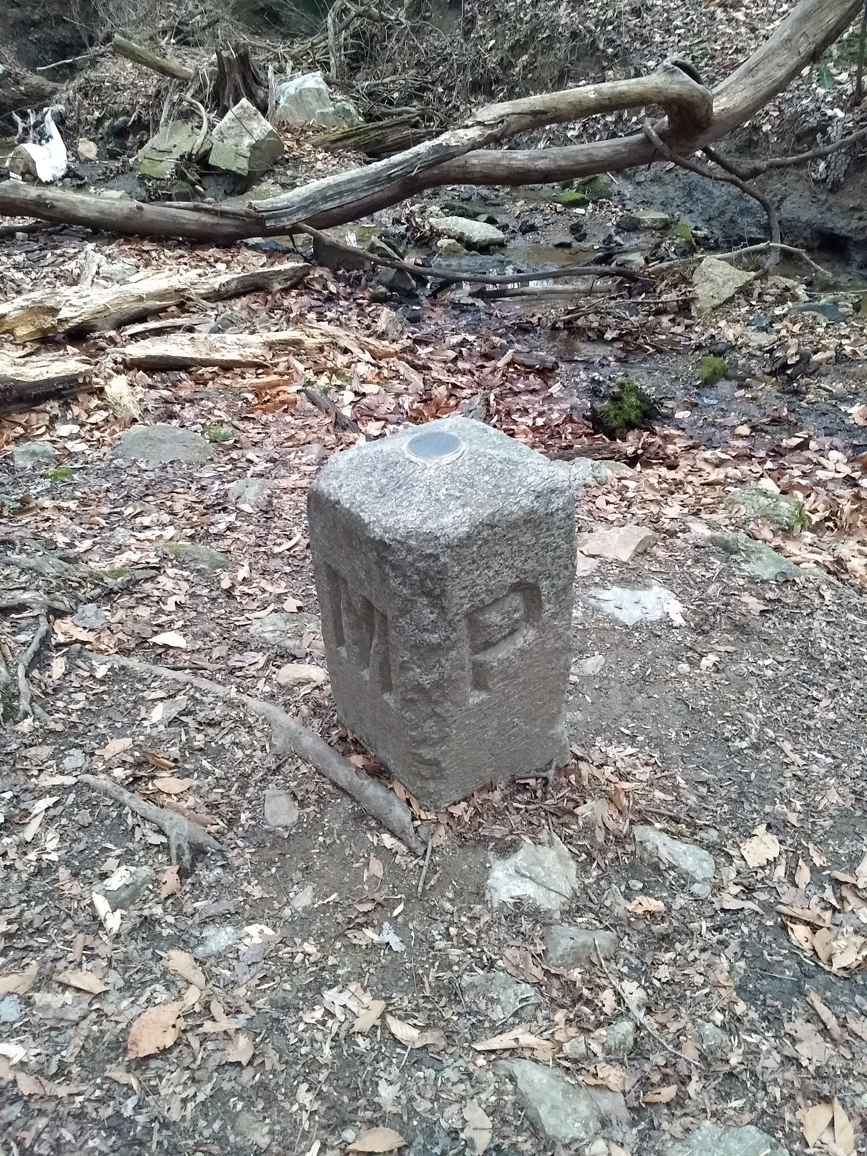
As you see, the Pennsylvania sides of the monument are marked with ‘P’ and the Maryland side with ‘M’. The other ‘M’ is actually in Delaware. This Newark Post article explains why there is no ‘D’:
The marker lists only Maryland and Pennsylvania, not Delaware, because in 1765, Delaware was part of Pennsylvania.
This does not explain the whole thing. The point was first marked in 1765 by Mason and Dixon and at that time Delaware was indeed part of Pennsylvania. But as you see the stone marker was placed in 1849, by which time Delaware had been there for some time. Perhaps the people who installed the new marker were trying to pretend that Delaware did not exist.
[ Addendum 20201218: Daniel Wagner points out that even if the 1849 people were trying to depict things as they were in 1765, the marker is still wrong; it should have three ‘P’ and one ‘M’, not two of each. I did read that the surveyors who originally placed the 1849 marker put it in the wrong spot, and it had to be moved later, so perhaps they were just not careful people. ]
Theron Stanford notes that this point is also the northwestern corner of the Wedge. This sliver of land was east of the Maryland border, but outside the Twelve-Mile Circle and so formed an odd prodtrusion from Pennsylvania. Pennsylvania only reliquinshed claims to it in 1921 and it is now agreed to be part of Delaware. Were the Wedge still part of Pennsylvania, the tripoint would have been at its southernmost point.
Looking at the map now I see that to get to the marker, I must have driven within a hundred yards of the westmost point of the Twelve-Mile Circle itself, and there is a (somewhat more impressive) marker there. Had I realized at the time I probably would have tried to stop off.
I have some other pictures of the marker if you are not tired of this yet.
[ Addendum 20201211: Tim Heany asks “Is there no sign at the border on 896?” There probably is, and this observation is a strong argument that I parked the car in Maryland. ]
[ Addendum 20201211: Yes, ‘prodtrusion’ was a typo, but it is a gift from the Gods of Dada and should be treasured, not thrown in the trash. ]
[Other articles in category /misc] permanent link