Mark Dominus (陶敏修)
mjd@pobox.com

Archive:
| 2026: | JFMAMJ |
| JA | |
| 2025: | JFMAMJ |
| JASOND | |
| 2024: | JFMAMJ |
| JASOND | |
| 2023: | JFMAMJ |
| JASOND | |
| 2022: | JFMAMJ |
| JASOND | |
| 2021: | JFMAMJ |
| JASOND | |
| 2020: | JFMAMJ |
| JASOND | |
| 2019: | JFMAMJ |
| JASOND | |
| 2018: | JFMAMJ |
| JASOND | |
| 2017: | JFMAMJ |
| JASOND | |
| 2016: | JFMAMJ |
| JASOND | |
| 2015: | JFMAMJ |
| JASOND | |
| 2014: | JFMAMJ |
| JASOND | |
| 2013: | JFMAMJ |
| JASOND | |
| 2012: | JFMAMJ |
| JASOND | |
| 2011: | JFMAMJ |
| JASOND | |
| 2010: | JFMAMJ |
| JASOND | |
| 2009: | JFMAMJ |
| JASOND | |
| 2008: | JFMAMJ |
| JASOND | |
| 2007: | JFMAMJ |
| JASOND | |
| 2006: | JFMAMJ |
| JASOND | |
| 2005: | OND |
In this section:
| Geeking out over arbitrary boundaries |
| Stuff that is and isn't backwards in Australia |
| Stuff that is backwards in Australia |
| Worst waterfall in the U.S. and Doug Burgum pays me $19 |
Subtopics:
| Mathematics | 251 |
| Programming | 102 |
| Language | 98 |
| Miscellaneous | 75 |
| Book | 51 |
| Tech | 49 |
| Etymology | 36 |
| Haskell | 33 |
| Oops | 30 |
| Unix | 27 |
| Cosmic Call | 25 |
| Math SE | 25 |
| Law | 23 |
| Physics | 21 |
| Perl | 17 |
| Biology | 16 |
| Brain | 15 |
| Calendar | 15 |
| Food | 15 |


Comments disabled
Sun, 14 Apr 2024
Stuff that is and isn't backwards in Australia
I recently wrote about things that are backwards in Australia. I made this controversial claim:
The sun in the Southern Hemisphere moves counterclockwise across the sky over the course of the day, rather than clockwise. Instead of coming up on the left and going down on the right, as it does in the Northern Hemisphere, it comes up on the right and goes down on the left.
Many people found this confusing and I'm not sure our minds met on this. I am going to try to explain and see if I can clear up the puzzles.
“Which way are you facing?” was a frequent question. “If you're facing north, it comes up on the right, not the left.”
(To prevent endless parenthetical “(in the Northern Hemisphere)” qualifications, the rest of this article will describe how things look where I live, in the northern temperate zones. I understand that things will be reversed in the Southern Hemisphere, and quite different near the equator and the poles.)
Here's what I think the sky looks like most of the day on most of the days of the year:
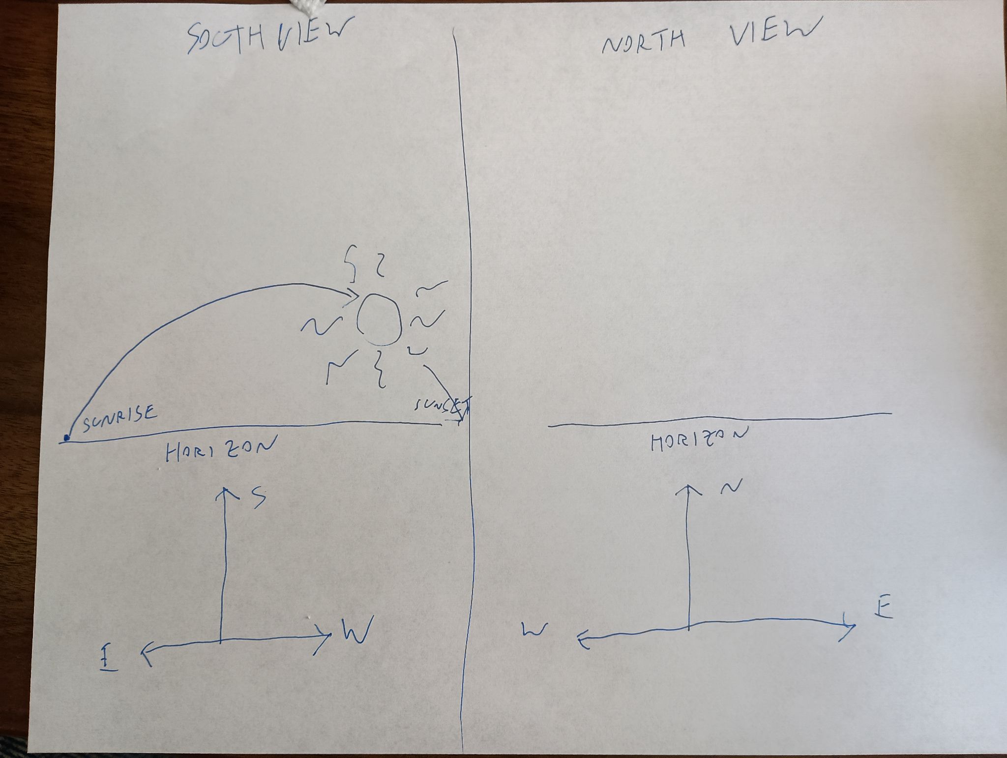
The sun is in the southern sky through the entire autumn, winter, and spring. In summer it is sometimes north of the celestial equator, for up to a couple of hours after sunrise and before sunset, but it is still in the southern sky most of the time. If you are watching the sun's path through the sky, you are looking south, not north, because if you are looking north you do not see the sun, it is behind you.
Some people even tried to argue that if you face north, the sun's path is a counterclockwise circle, rather than a clockwise one. This is risible. Here's my grandfather's old grandfather clock. Notice that the hands go counterclockwise! You study the clock and disagree. They don't go counterclockwise, you say, they go clockwise, just like on every other clock. Aha, but no, I say! If you were standing behind the clock, looking into it with the back door open, then you would clearly see the hands go counterclockwise! Then you kick me in the shin, as I deserve.
Yes, if you were to face away from the sun, its path could be said to be counterclockwise, if you could see it. But that is not how we describe things. If I say that a train passed left to right, you would not normally expect me to add “but it would have been right to left, had I been facing the tracks”.
At least one person said they had imagined the sun rising directly ahead, then passing overhead, and going down in back. Okay, fair enough. You don't say that the train passed left to right if you were standing on the tracks and it ran you down.
Except that the sun does not pass directly overhead. It only does that in the tropics. If this person were really facing the sun as it rose, and stayed facing that way, the sun would go up toward their right side. If it were a train, the train tracks would go in a big curve around their right (south) side, from left to right:
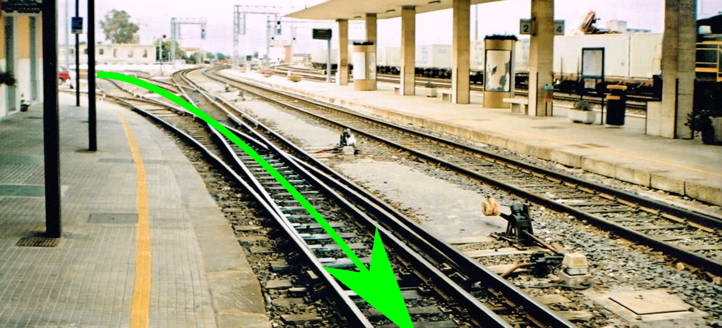
Mixed gauge track (950 and 1435mm) at Sassari station, Sardinia, 1996 by user Afterbrunel, CC BY-SA 3.0 DEED, via Wikimedia Commons. I added the big green arrows.
After the train passed, it would go back the other way, but they wouldn't be able see it, because it would be behind them. If they turned around to watch it go, it would still go left to right:

And if they were to turn to follow it over the course of the day, they would be turning left to right the whole time, and the sun would be moving from left to right the whole time, going up on the left and coming down on the right, like the hands of a clock — “clockwise”, as it were.
One correspondent suggested that perhaps many people in technologically advanced countries are not actually familiar with how the sun and moon move, and this was the cause of some of the confusion. Perhaps so, it's certainly tempting to dismiss my critics as not knowing how the sun behaves. The other possibility is that I am utterly confused. I took Observational Astronomy in college twice, and failed both times.
Anyway, I will maybe admit that “left to right” was unclear. But I will not recant my claim that the sun moves clockwise. E pur si muove in senso orario.
Sundials
Here I was just dead wrong. I said:
In the Northern Hemisphere, the shadow of a sundial proceeds clockwise, from left to right.
Absolutely not, none of this is correct. First, “left to right”. Here's a diagram of a typical sundial:

It has a sticky-up thing called a ‘gnomon’ that casts a shadow across the numbers, and the shadow moves from left to right over the course of the day. But obviously the sundial will work just as well if you walk around and look at it from the other side:

It still goes clockwise, but now clockwise is right to left instead of left to right.
It's hard to read because the numerals are upside down? Fine, whatever:

Here, unlike with the sun, “go around to the other side” is perfectly reasonable.
Talking with Joe Ardent, I realized that not even “clockwise” is required for sundials. Imagine the south-facing wall of a building, with the gnomon sticking out of it perpendicular. When the sun passes overhead, the gnomon will cast a shadow downwards on the wall, and the downward-pointing shadow will move from left to right — counterclockwise — as the sun makes its way from east to west. It's not even far-fetched. Indeed, a search for “vertical sundials” produced numerous examples:
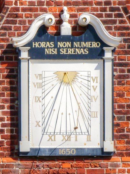
Sundial on the Moot Hall by David Dixon, CC BY 2.0 https://creativecommons.org/licenses/by/2.0, via Wikimedia Commons and Geograph.
Winter weather on July 4
Finally, it was reported that there were complaints on Hacker News that Australians do not celebrate July 4th. Ridiculous! All patriotic Americans celebrate July 4th.
[Other articles in category /geo] permanent link
Sun, 31 Mar 2024
Stuff that is backwards in Australia
I thought at first this was going to be kind of a dumb article, because it was just going to be a list of banal stuff like:
- When it's day here, it's night there, and vice versa
but a couple of years back I was rather startled to realize that in the Southern Hemisphere the sun comes up on the right and goes counterclockwise through the sky instead of coming up on the left and going clockwise as I have seen it do all my life, and that was pretty interesting.
Then more recently I was thinking about it more carefully and I was stunned when I realized that the phases of the moon go the other way. So I thought I'd should actually make the list, because a good deal of it is not at all obvious. Or at least it wasn't to me!
When it's day here, it's night there, and vice versa. (This isn't a Southern Hemisphere thing, it's an Eastern Hemisphere thing.)
When it's summer here, it's winter there, and vice versa. Australians celebrate Christmas by going to the beach, and July 4th with sledding and patriotic snowball fights.
Australia's warmer zones are in the north, not the south. Their birds fly north for the winter. But winter is in July, so the reversals cancel out and birds everywhere fly south in September and October, and north in March and April, even though birds can't read.
The sun in the Southern Hemisphere moves counterclockwise across the sky over the course of the day, rather than clockwise. Instead of coming up on the left and going down on the right, as it does in the Northern Hemisphere, it comes up on the right and goes down on the left.
In the Northern Hemisphere, the shadow of a sundial proceeds clockwise, from left to right. (This is the reason clock hands also go clockwise: for backward compatibility with sundials.) But in the Southern Hemisphere, the shadow on a sundial goes counterclockwise.
In the Southern Hemisphere, the designs on the moon appear upside-down compared with how they look in the Northern Hemisphere. Here's a picture of the full moon as seen from the Northern Hemisphere. The big crater with the bright rays that is prominent in the bottom half of the picture is Tycho.
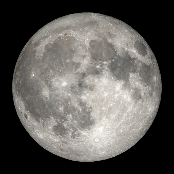
In the Southern Hemisphere the moon looks like this, with Tycho on top:
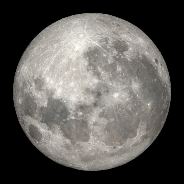
Australians see the moon upside-down because their heads are literally pointing in the opposite direction.
For the same reason, the Moon's phases in the Southern Hemisphere sweep from left to right instead of from right to left. In the Northern Hemisphere they go like this as the month passes from new to full:


And then in the same direction from full back to new:


But in the Southern Hemisphere the moon changes from left to right instead:


And then:


Unicode U+263D and U+263E are called
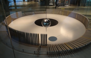
FIRST QUARTER MOON☽ andLAST QUARTER MOON☾ , respectively, and are depicted Northern Hemisphere style. (In the Southern Hemisphere, ☽ appears during the last quarter of the month, not the first.) Similarly the emoji U+1F311 through U+1F318, 🌑🌒🌓🌔🌕🌖🌗🌘 are depicted in Northern Hemisphere order, and have Northern Hemisphere descriptions like “🌒 waxing crescent moon”. In the Southern Hemisphere, 🌒 is actually a waning crescent.In the Northern Hemisphere a Foucault pendulum will knock down the pins in clockwise order, as shown in the picture. (This one happens to be in Barcelona.) A Southern Hemisphere Foucault pendulum will knock them down in counterclockwise order, because the Earth is turning the other way, as viewed from the fulcrum of the pendulum.
Northern Hemisphere tornadoes always rotate counterclockwise. Southern Hemisphere tornadoes always rotate clockwise.

_at_Sassari_station,_Sardinia,_1996.jpg)
Dishonorable mention
As far as I know the thing about water going down the drain in one direction or the other is not actually true.
Addendum 20240414
Several people took issue with some of the claims in this article, and the part about sundials was completely wrong. I wrote a followup.
[Other articles in category /geo] permanent link
Fri, 04 Aug 2023
Worst waterfall in the U.S. and Doug Burgum pays me $19
North Dakota is not a place I think about much, but it crossed paths with me twice in July.
Waterfalls
Last month I suddenly developed a burning need to know: if we were to rank the U.S. states by height of highest waterfall, which state would rank last? Thanks to the Wonders of the Internet I was able to satisfy this craving in short order. Delaware is the ⸢winner⸣, being both very small and very flat.
In looking into this, I also encountered the highest waterfall in North Dakota, Mineral Springs Waterfall. (North Dakota is also noted for being rather flat. It is in the Great Plains region of North America.)
The official North Dakota tourism web site (did you know there was one? I didn't.) has a page titled “North Dakota has a Waterfall?” which claims an 8-foot (2.4m) drop.
The thing I want you to know, though, is that they include this ridiculous picture on the web site:
Wow, pathetic. As Lorrie said, “it looks like a pipe burst.”
The World Waterfall Database claims that the drop is 15 feet (5m). The WWD is the source cited in the official USGS waterfall data although the USGS does not repeat WWD's height claim.
I am not sure I trust the WWD. It seems to have been abandoned. I wrote to all their advertised contact addresses to try to get them to add Wadhams Falls, but received no response.
Doug Burgum
Doug Burgum is some rich asshole, also the current governor of North Dakota, who wants to be the Republican candidate for president in the upcoming election.
To qualify for the TV debate next month, one of the bars he had to clear was to have received donations from 40,000 individuals, including at least 200 from each of 20 states. But how to get people to donate? Who outside of North Dakota has heard of Doug Burgum? Certainly I had not.
If you're a rich asshole, the solution is obvious: just buy them. For a while (and possibly still) Burgum was promising new donors to his campaign a $20 debit card in return for a donation of any size.
Upside: Get lots of free media coverage, some from channels like NPR that would normally ignore you. Fifty thousand new people on your mailing list. Get onstage in the debate. And it costs only a million dollars. Money well spent!
Downside: Reimbursing people for campaign donations is illegal, normally because it would allow a single donor to evade the limits on individual political contributions. Which is what this is, although not for that reason; here it is the campaign itself reimbursing the contributions.
Anyway, I was happy to take Doug Burgum's money. (A middle-class lesson I tried to instill into the kids: when someone offers you free money, say yes.) I donated $1, received the promised gift card timely, and immediately transferred the money to my transit card.
I was not able to think of a convincing argument against this:
But it's illegal For him. Not for me.
But you're signing up to receive political spam I unsubscribed right away, and it's not like I don't get plenty of political spam already.
But he'll sell your address to his asshole friends His list may not be a hot seller. His asshole friends will know they're buying a list of people who are willing donate $1 in return for a $20 debit card; it's not clear why anyone would want this. If someone does buy it, and they want to make me the same offer, I will be happy to accept. I'll take free money from almost anyone, the more loathsome the better.
But you might help this asshole get elected If Doug Burgum were to beat Trump to the nomination, I would shout from the rooftops that I was proud to be part of his victory.
If Doug Burgum is even the tiniest speedbump on Trump's path to the nomination, it will be negative $19 well-spent.
But it might give him better chances in the election of 2028 I have no reason to think that Burgum would be any worse than any other rich asshole the Republicans might nominate in 2028.
Taking Doug Burgum's $19 was time well-spent, I would do it again.
Addendum: North Dakota tourism
Out of curiosity about the attractions of North Dakota tourism, I spent a little while browsing the North Dakota tourism web site, wondering if the rest of it was as pitiful and apologetic as the waterfall page.
No! They did a great job of selling me on North Dakota tourism. The top three items on the “Things to Do” page are plausible and attractive:
“Nature and Outdoors Activities”, with an excellent picture of a magnificent national park and another of a bison. 100%, no notes.
Recreation. The featured picture is a beaming fisherman holding up an enormous fish; other pictures boast “hiking” and “hunting”.
History. The featured picture is Lakota Sioux in feathered war bonnets.
Good stuff. I had hoped to visit anyway, and the web site has gotten me excited to do it.
[Other articles in category /geo] permanent link
Wed, 24 Jun 2020
Geeking out over arbitrary boundaries
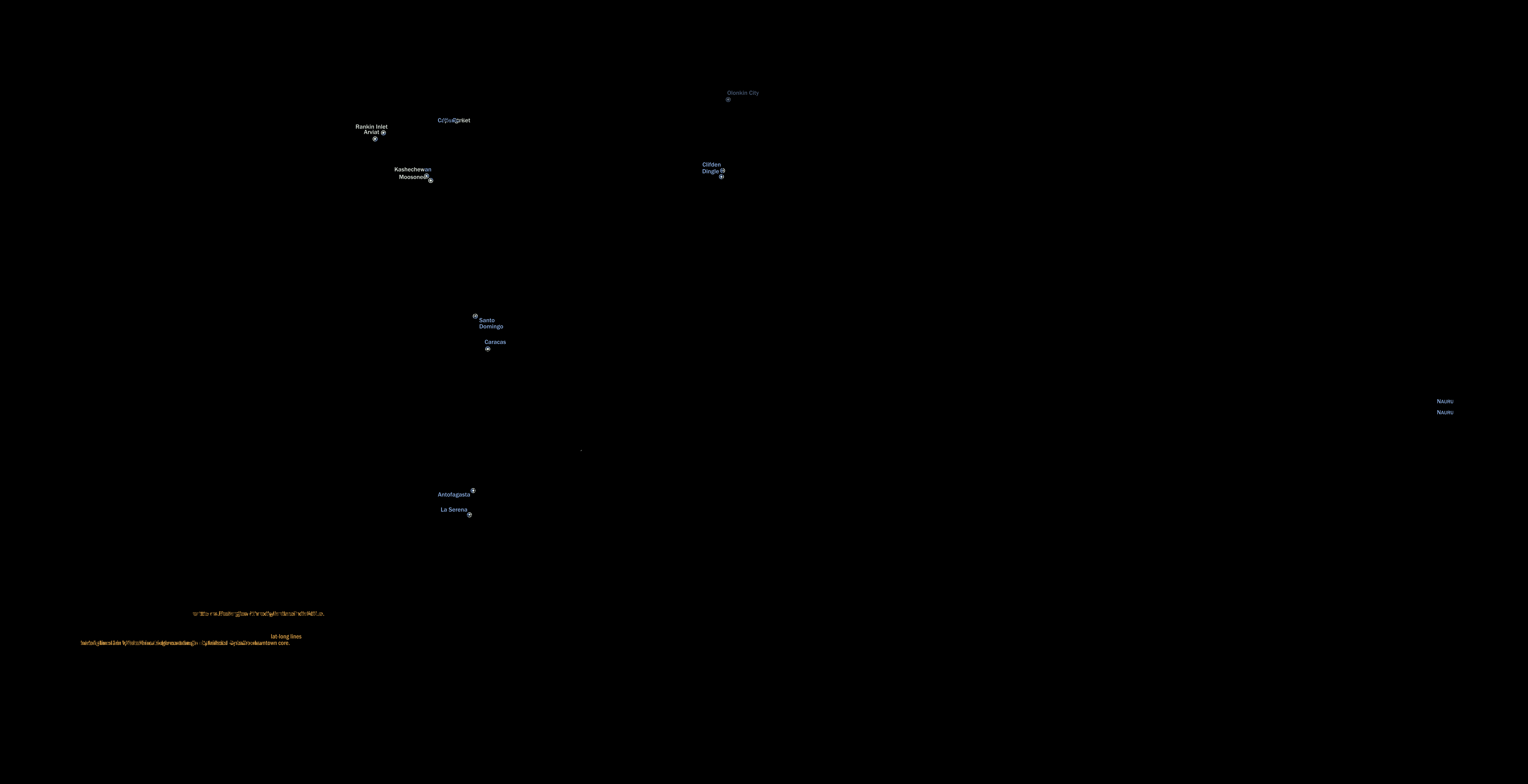
Reddit today had this delightful map, drawn by Peter Klumpenhower, of “the largest city in each 10-by-10 degree area of latitude-longitude in the world”:
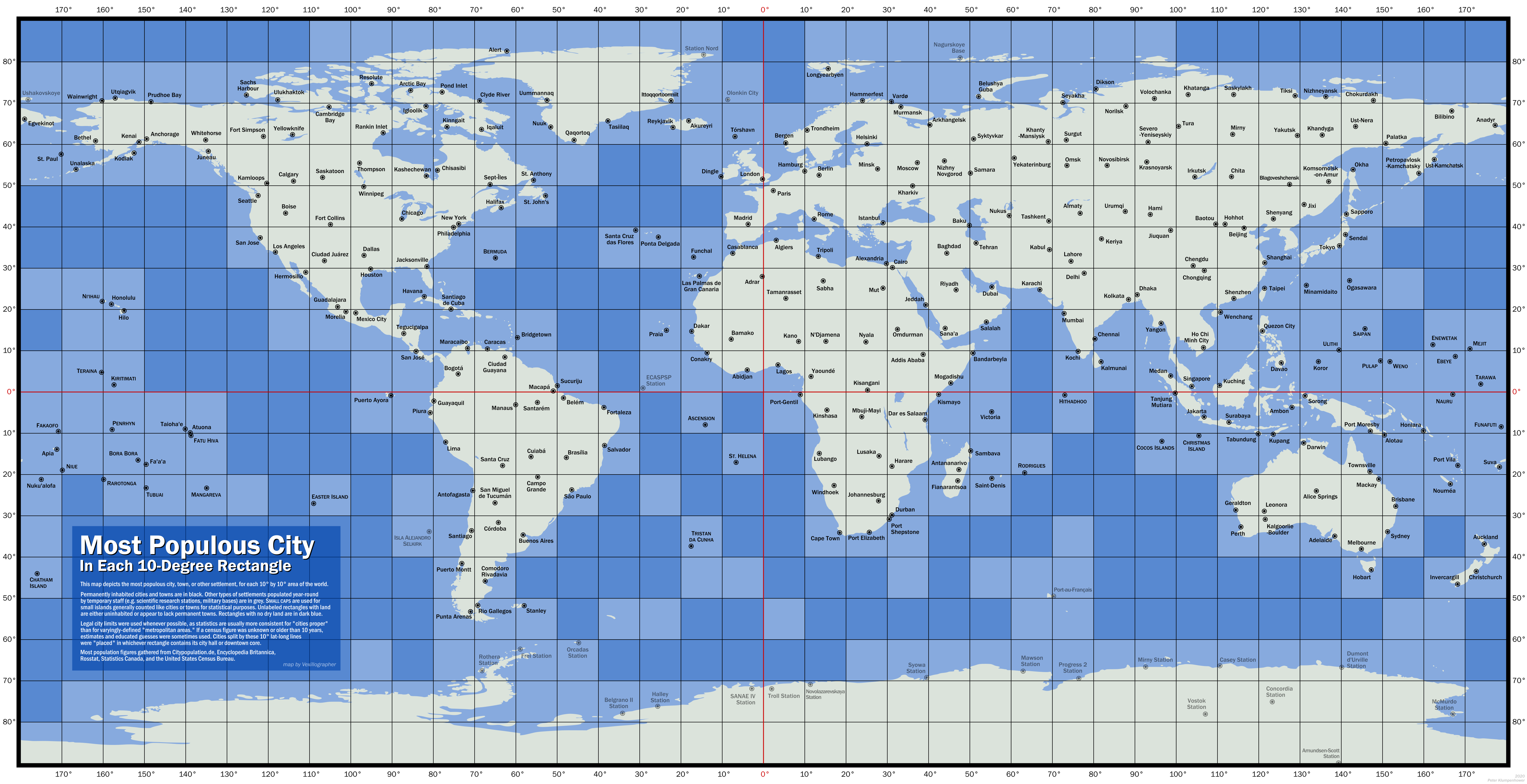
(Click to enlarge.)
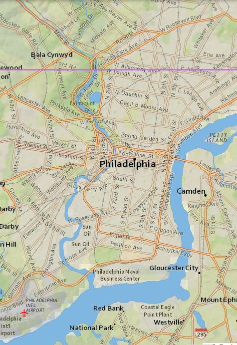
Almost every square is a kind of puzzle! Perhaps it is surprising that Philadelphia is there? Clearly New York dominates its square, but Philadelphia is just barely across the border in the next square south: the 40th parallel runs right through North Philadelphia. (See map at right.) Philadelphia City Hall (the black dot on the map) is at 39.9524 north latitude.
This reminds me of the time I was visiting Tom Christiansen in Boulder, Colorado. We were driving on Baseline Road and he remarked that it was so named because it runs exactly along the 40th parallel. Then he said “that's rather farther south than where you live”. And I said no, the 40th parallel also runs through Philadelphia! Other noteworthy cities at this latitude include Madrid, Ankara, Yerevan, and Beijing.
Anyway speaking of Boulder, the appearance of Fort Collins was the first puzzle I noticed. If you look at the U.S. cities that appear on the map, you see most of the Usual Suspects: New York, Philadelphia, Chicago, Los Angeles, Seattle, Dallas, Houston. And then you have Fort Collins.
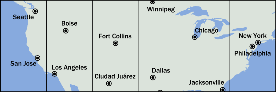
“Fort Collins?” I said. “Why not Denver? Or even Boulder?”
Boulder, it turns out, is smaller than Fort Collins. (I did not know this.) And Denver, being on the other side of Baseline Road, doesn't compete with Fort Collins. Everything south of Baseline Road, including Denver, is shut out by Ciudad Juárez, México (population 1.5 million).
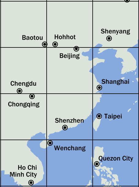
There is a Chinese version of this. The Chinese cities on the map include the big Chinese cities: Shanghai, Beijing, Chongqing, Shenzhen, Chengdu. Shenyang. A couple of cities in Inner Mongolia, analogous to the appearance of Boise on the U.S. map. And…
Wenchang. What the heck is Wenchang?
It's the county seat of Wenchang County, in Hainan, not even as important as Fort Collins. China has 352 cities with populations over 125,000. Wenchang isn't one of them. According to the list I found, Wenchang is the 379th-largest city in China. (Fort Collins, by the way, is 159th-largest in the United States. For the 379th, think of Sugar Land, Texas or Cicero, Illinois.)
Since we're in China, please notice how close Beijing is to the 40th parallel. Ten kilometers farther north and it would have displaced Boise — sorry, I meant Hohhot — and ceded its box to Tianjin (pop. 15.6 million). Similarly (but in reverse), had Philadelphia been a bit farther north, it would have disappeared into New York's box, and yielded its own box to Baltimore or Washington or some other hamlet.
Opposite to the “what the heck is?" puzzles are there “what the heck
happened to?” puzzles. Some are easier than others. It's obvious
what happened to Seoul: it's in the same box as Shanghai. The largest
missing U.S. city is Phoenix, which you can probably guess is in the same box as Los Angeles.
But what the heck happened to Nairobi? (Nairobi is the ninth-largest city in Africa. Dar Es Salaam is the sixth-largest and is in the same box.)
What the heck happened to St. Petersburg? (at 59.938N, 30.309E, it is just barely inside the same box as Moscow. The map is quite distorted in this region.)
What the heck happened to Tashkent? (It's right where it should be. I just missed it somehow.)
 There are some boxes where there just isn't much
space for cities. Some of these are obvious: most of Micronesia;
notoriously isolated places like Easter Island, Tristan Da Cunha, and
St. Helena; other islands like Ni‘ihau, Saipan, and Bermuda. But some
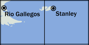
are less obvious. We saw Wenchang already. Most of West Falkland
Island is in the same box as
Río Gallegos, Argentina (pop.
98,000). But the capital, Stanley,
(pop. 2,460) is on the East Island, in the next box over.
There are some boxes where there just isn't much
space for cities. Some of these are obvious: most of Micronesia;
notoriously isolated places like Easter Island, Tristan Da Cunha, and
St. Helena; other islands like Ni‘ihau, Saipan, and Bermuda. But some
are less obvious. We saw Wenchang already. Most of West Falkland
Island is in the same box as
Río Gallegos, Argentina (pop.
98,000). But the capital, Stanley,
(pop. 2,460) is on the East Island, in the next box over.
 Okay, enough islands. Some of those little
towns, alone in their boxes, are on the mainland and (unlike, say, Ittoqqortoormiit) in places where
people actually live. But they just happened to get lucky and be the only town in
their box. Gabon isn't a big part of Africa.
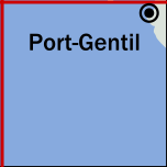
Port-Gentil (pop. 136,462) isn't the largest city
in Gabon. But it's on the mainland of Africa and it's the largest city in its box.
Okay, enough islands. Some of those little
towns, alone in their boxes, are on the mainland and (unlike, say, Ittoqqortoormiit) in places where
people actually live. But they just happened to get lucky and be the only town in
their box. Gabon isn't a big part of Africa.
Port-Gentil (pop. 136,462) isn't the largest city
in Gabon. But it's on the mainland of Africa and it's the largest city in its box.
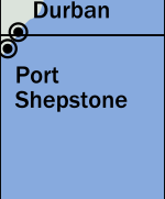 I think my favorite oddity so far is that Maputo (population 2.7 million) would have won in its box,
if Durban (population 3.7 million) were 13 kilometers farther south.
But Durban is at 29.9°S, and that means that the largest settlement
in Africa east of 30°E that is also south of 30°S is
Port Shepstone (pop. 35,633).
I think my favorite oddity so far is that Maputo (population 2.7 million) would have won in its box,
if Durban (population 3.7 million) were 13 kilometers farther south.
But Durban is at 29.9°S, and that means that the largest settlement
in Africa east of 30°E that is also south of 30°S is
Port Shepstone (pop. 35,633).
[ Addendum: Reddit discussion has pointed out that Clifden (pop. 1,597) , in western Ireland, is not the largest settlement in its box. There are two slivers of Ireland in that box, and Dingle, four hours away in County Kerry, has a population of 2,050. The Reddit discussion has a few other corrections. The most important is probably that Caracas should beat out Santo Domingo. M. Klumpenhower says that they will send me a revised version of the map. ]
[ Thanks to Hacker News user oefrha for pointing out that Hohhot and Baotou are in China, not Mongolia as I originally said. ]
[ Addendum 20200627: M. Klumpenhower has sent me a revised map, which now appears in place of the old one. It corrects the errors mentioned above. Here's a graphic that shows the differences. But Walt Mankowski pointed out another possible error: The box with Kochi (southern India) should probably be owned by Colombo. ]
[Other articles in category /geo] permanent link