Mark Dominus (陶敏修)
mjd@pobox.com

Archive:
| 2026: | JFMAMJ |
| 2025: | JFMAMJ |
| JASOND | |
| 2024: | JFMAMJ |
| JASOND | |
| 2023: | JFMAMJ |
| JASOND | |
| 2022: | JFMAMJ |
| JASOND | |
| 2021: | JFMAMJ |
| JASOND | |
| 2020: | JFMAMJ |
| JASOND | |
| 2019: | JFMAMJ |
| JASOND | |
| 2018: | JFMAMJ |
| JASOND | |
| 2017: | JFMAMJ |
| JASOND | |
| 2016: | JFMAMJ |
| JASOND | |
| 2015: | JFMAMJ |
| JASOND | |
| 2014: | JFMAMJ |
| JASOND | |
| 2013: | JFMAMJ |
| JASOND | |
| 2012: | JFMAMJ |
| JASOND | |
| 2011: | JFMAMJ |
| JASOND | |
| 2010: | JFMAMJ |
| JASOND | |
| 2009: | JFMAMJ |
| JASOND | |
| 2008: | JFMAMJ |
| JASOND | |
| 2007: | JFMAMJ |
| JASOND | |
| 2006: | JFMAMJ |
| JASOND | |
| 2005: | OND |
Subtopics:
| Mathematics | 250 |
| Programming | 102 |
| Language | 97 |
| Miscellaneous | 75 |
| Book | 50 |
| Tech | 49 |
| Etymology | 36 |
| Haskell | 33 |
| Oops | 30 |
| Unix | 27 |
| Cosmic Call | 25 |
| Math SE | 25 |
| Law | 23 |
| Physics | 21 |
| Perl | 17 |
| Biology | 16 |
| Brain | 15 |
| Calendar | 15 |
| Food | 15 |


Comments disabled
Tue, 14 Jan 2020
More about triple border points
[ Previously ]
A couple of readers wrote to discuss tripoints, which are places where three states or other regions share a common border point.
Doug Orleans told me about the Tri-States Monument near Port Jervis, New York. This marks the approximate location of the Pennsylvania - New Jersey - New York border. (The actual tripoint, as I mentioned, is at the bottom of the river.)
I had independently been thinking about taking a drive around the entire border of Pennsylvania, and this is just one more reason to do that. (Also, I would drive through the Delaware Water Gap, which is lovely.) Looking into this I learned about the small town of North East, so-named because it's in the northeast corner of Erie County. It's also the northernmost point in Pennsylvania.
(I got onto a tangent about whether it was the northeastmost point in Pennsylvania, and I'm really not sure. It is certainly an extreme northeast point in the sense that you can't travel north, east, or northeast from it without leaving the state. But it would be a very strange choice, since Erie County is at the very western end of the state.)
My putative circumnavigation of Pennsylvanias would take me as close as possible to Pennsylvania's only international boundary, with Ontario; there are Pennsylvania - Ontario tripoints with New York and with Ohio. Unfortunately, both of them are in Lake Erie. The only really accessible Pennsylvania tripoints are the one with West Virginia and Maryland (near Morgantown) and Maryland and Delaware (near Newark).
These points do tend to be marked, with surveyors’ markers if nothing else. Loren Spice sent me a picture of themselves standing at the tripoint of Kansas, Missouri, and Oklahoma, not too far from Joplin, Missouri.
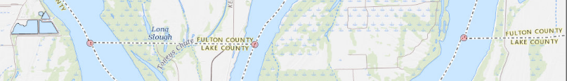
While looking into this, I discovered the Kentucky Bend, which is an exclave of Kentucky, embedded between Tennessee and Missouri:
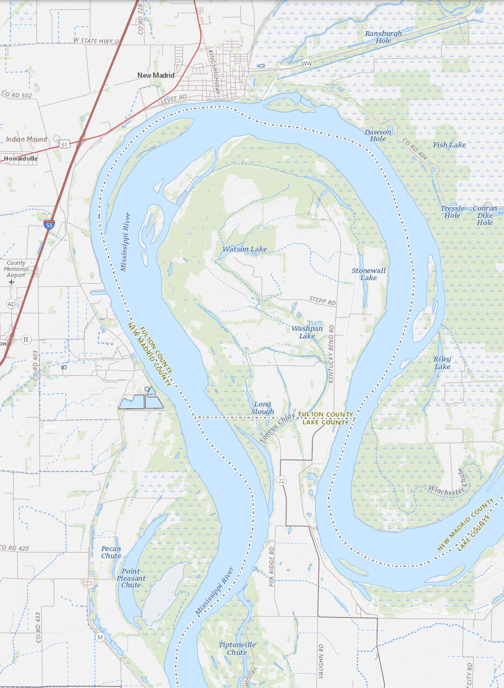
The “bubble” here is part of Fulton County, Kentucky. North, across the river, is New Madrid County, Missouri. The land border of the bubble is with Lake County, Tennessee.
It appears that what happened here is that the border between Kentucky and Missouri is the river, with Kentucky getting the territory on the left bank, here the south side. And the border between Kentucky and Tennessee is a straight line, following roughly the 36.5 parallel, with Kentucky getting the territory north of the line. The bubble is south of the river but north of the line.
So these three states have not one tripoint, but three, all only a few miles apart!
Finally, I must mention the Lakes of Wada, which are not real lakes, but rather are three connected subsets of the unit disc which have the property that every point on their boundaries is a tripoint.
[Other articles in category /misc] permanent link