Mark Dominus (陶敏修)
mjd@pobox.com

Archive:
| 2026: | J |
| 2025: | JFMAMJ |
| JASOND | |
| 2024: | JFMAMJ |
| JASOND | |
| 2023: | JFMAMJ |
| JASOND | |
| 2022: | JFMAMJ |
| JASOND | |
| 2021: | JFMAMJ |
| JASOND | |
| 2020: | JFMAMJ |
| JASOND | |
| 2019: | JFMAMJ |
| JASOND | |
| 2018: | JFMAMJ |
| JASOND | |
| 2017: | JFMAMJ |
| JASOND | |
| 2016: | JFMAMJ |
| JASOND | |
| 2015: | JFMAMJ |
| JASOND | |
| 2014: | JFMAMJ |
| JASOND | |
| 2013: | JFMAMJ |
| JASOND | |
| 2012: | JFMAMJ |
| JASOND | |
| 2011: | JFMAMJ |
| JASOND | |
| 2010: | JFMAMJ |
| JASOND | |
| 2009: | JFMAMJ |
| JASOND | |
| 2008: | JFMAMJ |
| JASOND | |
| 2007: | JFMAMJ |
| JASOND | |
| 2006: | JFMAMJ |
| JASOND | |
| 2005: | OND |
Subtopics:
| Mathematics | 245 |
| Programming | 100 |
| Language | 95 |
| Miscellaneous | 75 |
| Book | 50 |
| Tech | 49 |
| Etymology | 35 |
| Haskell | 33 |
| Oops | 30 |
| Unix | 27 |
| Cosmic Call | 25 |
| Math SE | 25 |
| Law | 22 |
| Physics | 21 |
| Perl | 17 |
| Biology | 16 |
| Brain | 15 |
| Calendar | 15 |
| Food | 15 |
Comments disabled
Sat, 06 Oct 2018
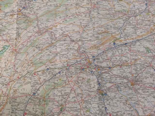
Last week we visited Toph's school and I saw a big map of Pennsylvania. I was struck by something I had never noticed before. Here's a detail of central Pennsylvania, an area roughly 100 miles (160 km) square:
As you can see, a great many lines on this map start in the lower left, proceed in roughly parallel tracks north-by-northeast, then bend to the right, ending in the upper right corner. Many of the lines represent roads, but some represent county borders, and some represent natural features such as forests and rivers.
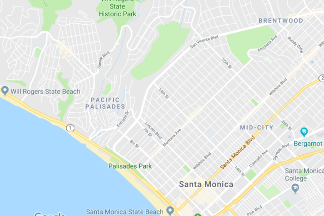
When something like this happens, it is almost always for some topographic reason. For example, here's a map of two adjacent communities in Los Angeles:
You can see just from the pattern of the streets that these two places must have different topography. The streets in Santa Monica are a nice rectangular grid. The streets in Pacific Palisades are in groups of concentric squiggles. This is because Pacific Palisades is hilly, and the roads go in level curves around the hills, whereas Santa Monica is as flat as a squid.
I had never noticed before that all the lines in central Pennsylvania go in the same direction. From looking at the map, one might guess that central Pennsylvania was folded into many long parallel wrinkles, and that the roads, forests, and rivers mostly lay in the valleys between the wrinkles. This is indeed the case. This part of Pennsylvania is part of the Ridge-and-Valley Appalachians, and the pattern of ridges and valleys extends far beyond Pennsylvania.
The wrinkling occurred over a long period, ending around 260 million years ago, in an event called the Alleghanian orogeny. North America and Africa (then part of the supercontinents Euramerica and Gondwana, respectively) collided with one another, and that whole part of North America crumpled up like a sheet of aluminum foil. People in Harrisburg and State College are living in the crumples.
[Other articles in category /misc] permanent link


